Sunday, September 10, 2017
9.50pm UPDATE:
AccuWeather Enterprise Solutions
SKYGUARD® HEAVY RAIN WARNING 1210
Prepared exclusively for The Tribune
Start Time: Sat, 09/09/2017, 04:00 AM EDT
Expire Time: Mon, 09/11/2017, 05:00 AM EDT
Locations: Freeport, Bahamas
Conditions: Heavy Rain
Comments: UPDATE
Hurricane Irma will bring flooding rains and destructive wind to the Freeport area through Sunday night. Additional bands of heavy rain are expected tonight with embedded thunderstorms. Some of these thunderstorms will be capable of generating tornadoes, increasing their destructive potential.
Storm total rainfall of 4-8 inches is likely, and when combined with a storm surge of 3-6 feet on the southern part of the island will result in widespread flooding.
Winds will gradually diminish tonight, decreasing from 30-40 mph with gusts to 60 mph this evening to 20-30 mph with gusts to near 40 mph early Monday morning. Conditions will rapidly improve during the day Monday. These strong winds can produce widespread downed trees and power lines, along with damage to some buildings.
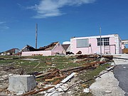
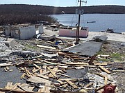
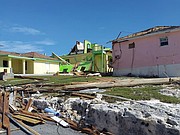
Damage on Ragged Island:
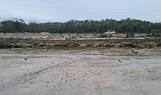
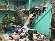
http://youtu.be/JuVRS6MdvGU http://youtu.be/vNojo31tkiU5.50pm UPDATE: Photos of storm damage in Ragged Island:
5.05pm UPDATE: Videos showing the aftermath of Hurricane Irma from Grand Bahama and Bimini:
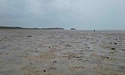
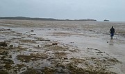
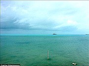
http://youtu.be/JVA2bEkTyEU http://youtu.be/pqz87Z9vCNs5.00pm UPDATE: These incredible pictures show Salt Pond, Long Island yesterday after Hurricane Irma pulled the water away from the shore. The water was expected to return gradually by today.
3.00pm UPDATE: MULTIPLE homes in Grand Bahama have been damaged as a result of tornadic activity due to Hurricane Irma, The Tribune was told - full story HERE
2.55pm UPDATE: Footage of flooding in Bimini:
http://youtu.be/EJlv-54sSX02.35pm UPDATE: Videos of hurricane damage and a tornado from Freeport (see weather warning below).
http://youtu.be/VYf3CahRPww http://youtu.be/hRC_x1BFVXMA weather warning for Freeport from AccuWeather Enterprise Solutions
SKYGUARD® HEAVY RAIN WARNING 1210
Prepared exclusively for Nassau Daily Tribune
Start Time: Sun, 09/10/2017, 04:00 AM EDT
Expire Time: Mon, 09/11/2017, 05:00 AM EDT
Locations: Freeport, Bahamas
Conditions: Heavy Rain
Comments: UPDATE
Major hurricane Irma will bring flooding rains and wind to the Freeport area through Sunday night. Multiple heavy rain bands are expected tonight with embedded thunderstorms. Some of these thunderstorms will be capable of generating tornadoes, increasing their destructive potential. The rain will become steadier later tonight with the heaviest rain likely to fall Sunday and Sunday evening.
Expected rainfall is 4-8 inches, with a 20% chance of 11 inches. This combined with a storm surge of 3-6 feet on the southern part of the island will result in widespread flooding.
Wind will be from the east this evening, shifting to the southeast late tonight and then eventually to the southeast on Sunday. Wind speeds will average 15-25 mph with gusts to 35 mph tonight, increasing to 40-! 50 mph sustained winds with gusts to 65-75 mph Sunday afternoon. Winds will gradually diminish late Sunday night into Monday. These strong winds can produce widespread downed trees and power lines, along with damage to some buildings. There can also be an isolated tornado.
Issued Time: Sun, 09/10/2017, 11:28 AM EDT
2.30pm UPDATE: Bahamas Academy-Reopening of Schools
Please be advised that all Teachers and Staff of Bahamas Academy Schools are asked to report to work on Monday September 11, 2017 at the usual time.
The campus will reopen for Students on September 12, 2017.
12.55pm UPDATE: Based on advice from The Meteorological Office, The Ministry of Education announces the following:
ADMINISTRATORS AND TEACHERS ON ISLANDS THAT HAVE BEEN GIVEN THE ‘ALL CLEAR’ BY NEMA / THE BAHAMAS MET OFFICE, ARE ASKED TO REPORT TO WORK ON MONDAY, SEPTEMBER 11th 2017 AT THE REGULARLY SCHEDULED TIME – the only exception being those islands where evacuations have taken place.
SCHOOL WILL REOPEN FOR STUDENTS ON ISLANDS GIVEN THE ALL CLEAR ON TUESDAY, SEPTEMBER 12th 2017 - again, the only exception being on those islands where evacuations have taken place.
Hurricane warnings are still in effect for Bimini and Grand Bahama, therefore
schools will remain closed on these islands until further notice.
Please note that if the ‘all clear’ is given in the next 12 hours for Bimini and Grand Bahama, another update will be released regarding school openings for those areas.
The Ministry of Education is taking all precautions to ensure that schools are fit to receive students.
THE PUBLIC IS ENCOURAGED TO DISREGARD ANY OTHER 'NOTICES' FROM UNOFFICIAL SOURCES
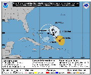
Sunday 11.00am UPDATE: As the new tracking map shows (main image), Florida is now feeling the force of Hurricane Irma.
Meanwhile, Hurricane Jose could potentially loop round later in the week and move into Bahamian waters, according to this NOAA tracking map.
6.15pm UPDATE: An audio clip of Minister of Health Dr Duane Sands talking about Hurricane Irma:
Audio clip
Minister of Health on Hurricane Irma
2.45pm UPDATE: Tribune iWitnessNews Mobile team can report that a Spring tide along with some of the tail end of Hurricane Irma is causing some unusually high tides along the Yamacraw area. (see videos above)
Motorists should be aware this has the potential for seawater to be spraying across some shore roads or roads to have some highly localised temporary flooding and be impassible.
Residents in the southern areas of New Providence should keep a watchful eye out for these developments with the rise and fall of high tide over the next couple of hours..
2.30pm UPDATE: AccuWeather has issued this heavy rain warning for Freeport - please note the update on the rainfall forcast being lowered slightly.
AccuWeather Enterprise Solutions
SKYGUARD® HEAVY RAIN WARNING 1210
Prepared exclusively for The Tribune
Start Time: Sat, 09/09/2017, 04:00 AM EDT
Expire Time: Sun, 09/10/2017, 11:00 PM EDT
Locations: Freeport, Eight Mile Rock, West End, Grand Bahama
Conditions: Heavy Rain
Major hurricane Irma will be impacting Florida in a few hours. As it works it way up the state it bring flooding rains and winds to the Freeport area through Sunday evening.
Much of the day Saturday rain will be intermittent, then becoming steadier Saturday night through Sunday.
There will also be a couple of thunderstorms. The worst conditions will occur between 6:00 pm Saturday and 4:00 pm Sunday.
Expected rainfall is 4-8 inches, with a 20% chance of 11 inches. This combined with a storm surge of 3-6 feet on the southern part of the island will result in potential widespread flooding.
Wind will be from the northeast late Friday night into Saturday morning, becoming east Saturday afternoon, southeast Sunday morning, then south on Sunday afternoon. Wind speeds late Friday night and Saturday will average 15-30 mph with gusts to 40-50 mph, increasing to 50-60 mph sustained winds with gusts to 65-80 mph Saturday night and Sunday, then gradually diminishing again late Sunday. These strong winds can produce widespread ! downed trees and power lines, along with damage to some buildings. There can also be an isolated tornado.
2.30pm UPDATE: A statement from Bahamsair on operations on Sunday:
Bahamasair wishes to advise the traveling public that we will resume limited operations on Sunday, September 10th 2017. It is our expectation, that we will resume services after 1:00pm into Freeport, Marsh Harbour, Rock Sound and Georgetown Exuma provided that the “ALL CLEAR” is given by the relevant authorities.
Please note our tentative operational schedule below:
FROM TO DEPARTS
Nassau - Rock Sound 3:00pm
Nassau - Freeport 4:00pm
Nassau - Marsh Harbour 5:00pm
Nassau - Georgetown, Exuma 5:00pm
Additionally, Bahamasair wishes to advise that normal operations will resume on Monday, September 11th 2017 based on weather and airport conditions. We note that our ability to resume services into Florida will be contingent on the opening of the airports in the cities we support, specifically Miami, Ft. Lauderdale, West Palm Beach & Orlando.
2.10pm UPDATE: All clear given for New Providence, Abaco, the Berry Islands and Eleuthera. Hurricane warnings remain for Andros, Bimini and Grand Bahama.
:
1.20pm UPDATE: A statement from the National Airport Development Company on conditions at LPIA:
The Nassau Airport Development Company wishes to advise that the Lynden Pindling International Airport sustained no damage from Hurricane Irma.
In view of the “All Clear” issued by the National Emergency Management Agency and the Meteorological Department, airport employees and stakeholders are asked to safely return to the airport to prepare for the prompt resumption of operations on Sunday, September 10, 2017.
The travelling public is encouraged to contact their respective airlines for flight information. A listing of all airlines and their contacts can be found on LPIA’s website at www.nassaulpia.com
The general public is asked to listen carefully to the local media for updates and to monitor LPIA’s website and social media channels at Facebook and Twitter.
http://youtu.be/ilpfaV1VxMo1.10pm UPDATE: THIS footage is reportedly from the Esso gas station on Baillou Hill Road - which was broken into as New Providence was awaiting the effects of Hurricane Irma. Gaining access through the roof, the thieves broke into a Royal Bank ATM, a BTC top up machine and the cash register. It is unknown how much cash they made off with.
12.15pm UPDATE: BTC has issued the following statement:
BTC advises that its network has been resilient and has fared well during the passage of Hurricane Irma.
The BTC Command Center and Emergency Teams, have been fully mobilized since Thursday for twenty four hour intense observation of the landline, internet, mobile and television networks and systems across the country. Most of our concerns are related to power, as there was a loss of commercial power in most islands. Based on our initial assessments, our local teams should be able to address most of the minor power issues in the islands.
We suspect major damage to our facilities in Ragged Island. Once the national “all-clear” has been provided, we will dispatch a technical team to assess the damage and begin the process of restoration.
The BTC Command Center will continue to monitor the hurricane until the “all-clear” has been provided for the rest of the country.
We are unable to give a comprehensive report at this time as we are still assessing the damage. As of 10am this morning, BTC can report the following:
Southeast Bahamas: The “all-clear” was given for the Southeast islands shortly after 10pm on September 8th.
All landline, internet and mobile services in Mayaguana, Rum Cay and Crooked Island are fully operational with localized service disruptions.
There is a loss of commercial power in Inagua affecting the Morton Salt mobile site. Once power is restored, the local team will assess the issues.
There is roof damage at our Cabbage Hill site in Crooked Hill. Our mobile sites in Long Cay, Cripple Hill, Majors Hill and Pitts Town are down due to a loss of commercial power.
There is a loss of commercial power in Acklins. Mobile sites at Mason Bay, Pompey Bay, and Pine Field are affected.
Our exchange building in Ragged Island is currently offline. Our teams will be dispatched to the island to investigate further once the national “all clear” is issued.
Long Island: There are intermittent landline and internet issues in Deadman’s Cay, Mooresville, Dunmore, Sunset Beach, Miller’s, Grays’s, Glinton, Mortimer’s settlements due to a loss of commercial power.
There are intermittent mobile issues with the Gordons/Mortimer’s, Stella Maris, Roses and Gray’s sites. There was a planned shut-down at the Lloyd’s Bar mobile site.
Exuma: There was a loss of commercial power. We are experiencing intermittent issues in Forbes Hill, Bay View, Steventon, Ramsey, Moss Town, Tar Bay, Hooper’s Bay and Ferry Bridge. There was a planned shut-down of the Fish Fry cellular tower. There were no issues on the Exuma Cays. There are intermittent landline and internet issues in Moss Town.
Cat Island: There was a loss of commercial power in Cat Island. We are experiencing intermittent issues in Hawks Nest.
Andros: There was a loss of commercial power in Andros. Customers in Kemp’s Bay and Mangrove Cay are experiencing intermittent data issues, however voice services are fully operational. The following sites are experiencing intermittent issues, Nicholl’s Town, Driggs Hill, Mars Bay, Little Harbour and BARC. Customers in Little Creek, Andros are also experiencing intermittent landline and internet issues due to a loss of commercial power.
Berry Island: Our networks and systems are operational
Eleuthera: There was a loss of commercial power. Mobile sites at the Governor’s Harbour Airport, Palmetto Point, Cape and Kohinoor are experiencing intermittent mobile issues. Landline and internet customers in Hidden Treasure are experiencing intermittent issues due to a loss of commercial power.
Grand Bahama: Our networks and systems are operational at this time.
Bimini: Our networks and systems are operational at this time.
San-Salvador: Our networks and systems are operational at this time.
New Providence: Our networks and systems are operational at this time.
There were no outages to our Flow TV and Flow to Go services being delivered thoughout The Bahamas. Mobile subscribers with a current data package were able to receive essential TV channels via our Flow To Go Mobile app.
We have been in direct contact with our business customers. Additionally, we’ve kept in constant contact with our critical service providers. All business services are operational and there are no issues to report.
BTC encourages the public to report any issues they may be experiencing to CALL-BTC (225-5282) or on our social media pages. We will continue to provide updates as we have additional details
11.40am UPDATE: The Bahamas Department of Meteorology issued this statement this morning at 9am:
THE MET DEPARTMENT ISSUED AN ALL CLEAR FOR THE CENTRAL BAHAMAS AND RAGGED ISLAND. THE CENTRAL BAHAMAS INCLUDES: LONG ISLAND, EXUMA, RUM CAY, SAN SALVADOR, AND CAT ISLAND.
HOWEVER, HURRICANE WARNINGS REMAIN IN EFFECT FOR THE NORTHWEST BAHAMAS. THIS INCLUDES THE ISLANDS OF GRAND BAHAMA, ABACO, BIMINI, THE BERRY ISLANDS, ANDROS, NEW PROVIDENCE AND ELEUTHERA.
.
9.10am UPDATE: A new NOAA map has been issued (main image). The red areas are under a hurricane warning - that includes the northwest and central Bahamas.
8.45am UPDATE: A CBS This morning report from Nassau describing a “profound sense of relief in the Bahamas”:
7.30am UPDATE: The latest tracking map from NOAA shows Hurricane Irma just to the north of Cuba, with Andros being hit by tropical storm conditions. A Hurricane Warning remains for the Northwest and Central Bahamas. Irma is currently a Category 4 storm.
